| Problem setting
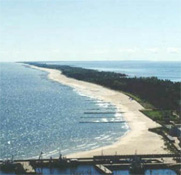
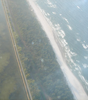
The peninsula is a sandy strip of land with the
majority of the area lying below 2.5 m. It is 34 km long
and its width varies from about 200 m in the narrowest part
to over 3 km at the tip. This spectacular land constitutes
a part of the coastal landscape park and is a famous recreational
resort for the Polish and foreign tourists. A road and a
railway run along the peninsula from the mainland to the
town located at the furthest point, Hel, a popular tourist
destination. The Hel Peninsula is an example of the area
with several mutually related coastal zone management problems
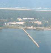
in Poland. Erosion has become a serious problem since the
construction of a harbour westwards of the Peninsula in
1936 – 1937. The harbour development has aggravated
the situation. Since the Peninsula is very narrow it may
be turned into an island by winter storms. Sand is supplied
in large quantities to beaches to avoid breaching the Hel
Peninsula.
Application of the frame of reference
approach
The project aims at implementing EUROSION concepts
into measurable standards, which can be used and evaluated
in practice for any field situation. According to the concept,
coastal erosion is a result of a sediment imbalance occurring
in a coastal sediment cell. The other key concepts are coastal
resilience as a strategic objective, a favourable sediment
status as an operational objective and a strategic sediment
reservoir as a management goal. Suitable Coastal State Indicators
(CSI’s) are developed that can link scientific knowledge,
measurements and modelling results to these management concepts.
Strategic objectives
In the case of the Hel Peninsula the preservation
of its coastal system has been selected as the strategic
objective.
Operational objectives
The selection of strategic objective implies definition
of two operational objectives:
- maintaining the beach width,
- preserving breaching.
Coastal sediment cell
The analysis indicates that the natural processes
responsible for the erosion along the Hel Peninsula and
affecting the management of the coast zone are longshore
sediment transport and storm-induced erosion. These two
processes have different time and spatial scales. The area
affected by the longshore transport covers the whole coastline
of the Hel Peninsula (34 km) and the time scale involved
counts in decades. The storm-induced erosion is a short
event that lasts several hours and affects certain parts
of the Hel Peninsula coastline in the order of kilometers.
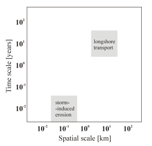
Hel Peninsula case study in the spatial – temporal
plane.
Having defined the objectives and processes,
the coastal cell boundaries can be established. According
to the coastal sediment cell definition, it contains a complete
cycle of sedimentation including sources, transport paths
and sinks. The coastal sediment cell must include all coastal
processes defined for the Hel Peninsula. Accordingly, the
western cell boundary constitutes the breakwater of Wladyslawowo
harbour that is impermeable for sand and a short section
of the open sea that can take part in the transfer of sediment
in the cell. Northern boundary of the coastal cell is an
open sea boundary. The eastern boundary is located at the
tip of the Hel Peninsula.
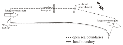
Sediment fluxes in the Hel Peninsula coastal cell.
In the presented coastal sediment cell natural
processes as well as artificial nourishment are taken into
account. The main cause of sand deficit in the cell is a
negative balance in the longshore sediment transport in
the long-term temporal scale.
Strategic sediment reservoirs
An important process that has to be taken into
consideration in the coastal cell is the artificial nourishment.
This process requires determination of a strategic sediment
reservoir for nourishment activities. In the case of Hel
Peninsula sand can be supplied from:
- the entrance channel to the Wladyslawowo harbour,
- offshore areas,
- Puck Bay and Gdansk Bay (under certain conditions).
Quantitative State Concept
Suitable Coastal State Indicators must be defined
in the applied approach to link scientific knowledge, measurements
and modelling results to management concepts. An analysis
of available reports regarding erosion problems indicates
that there is a set of parameters, which can be applied
in the management of the coastal zone for the Hel Peninsula:
- beach width: 30-40m
- beach height: 1.5-2.0m
- dune width: 40m
- maximum dune height: 4.5m
- dune section area: 180m2
- hinterland height: 2.5m
Update activities and recent research findings
- Conference paper prepared and presented on The 7th
International Symposium on Ecohydraulics 2009 –
January 2009,
- The new bathymetry and shoreline evolution data were
collected and are being analysed,
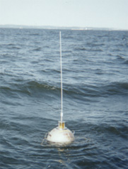
- Wave measurements campaign - the wave buoy was placed
near the tip of Hel Peninsula at 20 meters depth in October
2008. The data from measurements are being analysed.
Favourable sediment status and
coastal resilience
Collected data indicate complexity of the processes
undergoing along the Hel Peninsula. To achieve the strategic
objective more information and long-term data are necessary.
In particular, long-term data regarding the rate of the
sediment flux due to a longshore transport, cross-shore
transport, and artificial nourishment. All these activities
are necessary to identify a favourable sediment status that
can promote coastal resilience and, in consequence, to achieve
the strategic objective.
|